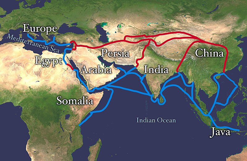
ဖိုင်:Silk route.jpg

ဤနမူနာ၏ အရွယ်အစား - ၈၀၀ × ၅၂၁ ပစ်ဇယ်။ အခြား ပုံရိပ်ပြတ်သားမှု: ၃၂၀ × ၂၀၈ ပစ်ဇယ် | ၆၄၀ × ၄၁၆ ပစ်ဇယ် | ၁၀၂၄ × ၆၆၆ ပစ်ဇယ် | ၁၂၈၀ × ၈၃၃ ပစ်ဇယ် | ၂၈၆၈ × ၁၈၆၆ ပစ်ဇယ်။
မူရင်းဖိုင် (၂၈၆၈ × ၁၈၆၆ pixels, ဖိုင်အရွယ်အစား - ၈၁၉ KB, MIME အမျိုးအစား image/jpeg)
ဖိုင်မှတ်တမ်း
ဖိုင်ကို ယင်းနေ့စွဲ အတိုင်း မြင်နိုင်ရန် နေ့စွဲ/အချိန် တစ်ခုခုပေါ်တွင် ကလစ်နှိပ်ပါ။
| နေ့စွဲ/အချိန် | နမူနာပုံငယ် | မှတ်တမ်း ဒိုင်မန်းရှင်းများ | အသုံးပြုသူ | မှတ်ချက် | |
|---|---|---|---|---|---|
| ကာလပေါ် | ၁၀:၃၈၊ ၄ ဇူလိုင် ၂၀၁၈ |  | ၂၈၆၈ × ၁၈၆၆ (၈၁၉ KB) | Bongan | sea route modify because of Rama Setu ({{Adam's Bridge}}) |
| ၁၄:၀၁၊ ၈ ဖေဖော်ဝါရီ ၂၀၁၈ |  | ၂၈၆၈ × ၁၈၆၆ (၁.၅၇ MB) | Darwgon0801 | Reverted to version as of 17:45, 30 December 2012 (UTC) | |
| ၀၇:၄၂၊ ၂၂ နိုဝင်ဘာ ၂၀၁၇ |  | ၂၈၆၈ × ၁၈၆၆ (၂.၀၆ MB) | Ibrahim Muizzuddin | Reverted to version as of 13:19, 12 April 2012 (UTC) Revert to more credible version | |
| ၁၇:၄၅၊ ၃၀ ဒီဇင်ဘာ ၂၀၁၂ |  | ၂၈၆၈ × ၁၈၆၆ (၁.၅၇ MB) | 23prootie~commonswiki | Adding Brunei and the Lucoes | |
| ၁၃:၁၉၊ ၁၂ ဧပြီ ၂၀၁၂ |  | ၂၈၆၈ × ၁၈၆၆ (၂.၀၆ MB) | Splette | correct typo | |
| ၁၀:၁၅၊ ၁၂ ဧပြီ ၂၀၁၂ |  | ၂၈၆၈ × ၁၈၆၆ (၂.၀၆ MB) | Splette | correct the position of the 'Somalia' label | |
| ၀၄:၅၁၊ ၂၇ မေ ၂၀၁၀ |  | ၂၈၆၈ × ၁၈၆၆ (၁.၉၃ MB) | Splette | one more try... better contrast | |
| ၀၄:၄၅၊ ၂၇ မေ ၂၀၁၀ |  | ၂၈၆၈ × ၁၈၆၆ (၁.၉၄ MB) | Splette | change colors | |
| ၀၄:၃၇၊ ၂၇ မေ ၂၀၁၀ |  | ၂၈၆၈ × ၁၈၆၆ (၁.၉၃ MB) | Splette | {{Information |Description=Extent of Silk Route/Silk Road. Red is land route and the blue is the sea/water route. |Source=*File:Whole_world_-_land_and_oceans_12000.jpg |Date=2010-05-27 04:33 (UTC) |Author=*[[:File:Whole_world_-_land_and_oceans_12000 |
ဖိုင်သုံးစွဲမှု
အောက်ပါ 2 စာမျက်နှာများ သည် ဤဖိုင်ကို အသုံးပြုထားသည်:
ဂလိုဘယ် ဖိုင်သုံးစွဲမှု
အောက်ပါ အခြားဝီကီများတွင် ဤဖိုင်ကို အသုံးပြုထားသည်-
- af.wikipedia.org တွင် အသုံးပြုမှု
- anp.wikipedia.org တွင် အသုံးပြုမှု
- ast.wikipedia.org တွင် အသုံးပြုမှု
- azb.wikipedia.org တွင် အသုံးပြုမှု
- az.wikipedia.org တွင် အသုံးပြုမှု
- ba.wikipedia.org တွင် အသုံးပြုမှု
- be-tarask.wikipedia.org တွင် အသုံးပြုမှု
- bg.wikipedia.org တွင် အသုံးပြုမှု
- bn.wikipedia.org တွင် အသုံးပြုမှု
- bs.wikipedia.org တွင် အသုံးပြုမှု
- ca.wikipedia.org တွင် အသုံးပြုမှု
- ce.wikipedia.org တွင် အသုံးပြုမှု
- chr.wikipedia.org တွင် အသုံးပြုမှု
- crh.wikipedia.org တွင် အသုံးပြုမှု
- da.wikipedia.org တွင် အသုံးပြုမှု
- de.wikipedia.org တွင် အသုံးပြုမှု
- el.wikipedia.org တွင် အသုံးပြုမှု
- el.wikivoyage.org တွင် အသုံးပြုမှု
- en.wikipedia.org တွင် အသုံးပြုမှု
ဤဖိုင်ကို အခြားနေရာများတွင် အသုံးပြုထားမှုများအား ကြည့်ရှုရန်။


