
ဖိုင်:Europe location SCO2.png

ဤနမူနာ၏ အရွယ်အစား - ၈၀၀ × ၅၉၉ ပစ်ဇယ်။ အခြား ပုံရိပ်ပြတ်သားမှု: ၃၂၀ × ၂၄၀ ပစ်ဇယ် | ၆၄၀ × ၄၇၉ ပစ်ဇယ် | ၁၀၂၄ × ၇၆၇ ပစ်ဇယ် | ၁၂၈၀ × ၉၅၉ ပစ်ဇယ် | ၁၅၉၄ × ၁၁၉၄ ပစ်ဇယ်။
မူရင်းဖိုင် (၁၅၉၄ × ၁၁၉၄ pixels, ဖိုင်အရွယ်အစား - ၅၅၈ KB, MIME အမျိုးအစား image/png)
| ဤဖိုင်သည် Wikimedia Commons မှဖြစ်ပြီး အခြားပရောဂျက်များတွင် သုံးကောင်းသုံးလိမ့်မည်။ ယင်း၏ ဖိုင်အကြောင်းစာမျက်နှာ တွင် ဖော်ပြထားချက်ကို အောက်တွင် ပြထားသည်။ Commons သည် မူပိုင်ခွင့်လွတ်လပ်သော မီဒီယာဖိုင်များ သိုလှောင်ထားရာ နေရာ ဖြစ်သည်။ သင်လည်း ပါဝင်ကူညီနိုင်ပါသည်။ |
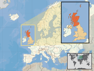
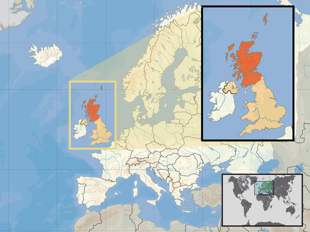
| ဖော်ပြချက် | Location of Scotland in the UK and Europe, on terrain map showing surface and underwater contour areas. | |||
| ရက်စွဲ | ||||
| ရင်းမြစ် | Derived from Wikimedia Commons image of original work forming part of the "Europe location" map series created by David Liuzzo: derived from Image:Europe_location_SCO.png. | |||
| စာရေးသူ | uploaded by User:Kmusser (excerpt from User:David_Liuzzo) | |||
| ခွင့်ပြုချက် (ဤဖိုင်ကို ပြန်လည်အသုံးပြုခြင်း) |
|
|||
| အခြား ဗားရှင်းများ |
|


ဖိုင်မှတ်တမ်း
ဖိုင်ကို ယင်းနေ့စွဲ အတိုင်း မြင်နိုင်ရန် နေ့စွဲ/အချိန် တစ်ခုခုပေါ်တွင် ကလစ်နှိပ်ပါ။
| နေ့စွဲ/အချိန် | နမူနာပုံငယ် | မှတ်တမ်း ဒိုင်မန်းရှင်းများ | အသုံးပြုသူ | မှတ်ချက် | |
|---|---|---|---|---|---|
| ကာလပေါ် | ၁၂:၃၉၊ ၁၀ ဧပြီ ၂၀၁၇ | | ၁၅၉၄ × ၁၁၉၄ (၅၅၈ KB) | Von Sprat | Reverted to version as of 12:25, 27 May 2010 (UTC) |
| ၁၂:၃၉၊ ၁၀ ဧပြီ ၂၀၁၇ |  | ၁၆၀၀ × ၁၂၀၀ (၇၈၈ KB) | Von Sprat | greece/turkey border | |
| ၁၂:၂၅၊ ၂၇ မေ ၂၀၁၀ |  | ၁၅၉၄ × ၁၁၉၄ (၅၅၈ KB) | Ras67 | cropped | |
| ၁၇:၃၁၊ ၂၉ စက်တင်ဘာ ၂၀၀၈ |  | ၁၆၀၀ × ၁၂၀၀ (၇၆၇ KB) | Kmusser | re-cropped inset to include Shetlands | |
| ၁၇:၂၂၊ ၂၉ စက်တင်ဘာ ၂၀၀၈ |  | ၁၆၀၀ × ၁၂၀၀ (၈၀၇ KB) | Kmusser | {{Information |Description= Location of Scotland in the UK and Europe, on terrain map showing surface and underwater contour areas. |Source=Derived from Wikimedia Commons image of original work forming part of the "Europe location" map series |
ဖိုင်သုံးစွဲမှု
အောက်ပါ စာမျက်နှာ သည် ဤဖိုင်ကို အသုံးပြုထားသည်:
ဂလိုဘယ် ဖိုင်သုံးစွဲမှု
အောက်ပါ အခြားဝီကီများတွင် ဤဖိုင်ကို အသုံးပြုထားသည်-
- als.wikipedia.org တွင် အသုံးပြုမှု
- an.wikipedia.org တွင် အသုံးပြုမှု
- az.wiktionary.org တွင် အသုံးပြုမှု
- ca.wikipedia.org တွင် အသုံးပြုမှု
- da.wikipedia.org တွင် အသုံးပြုမှု
- en.wikipedia.org တွင် အသုံးပြုမှု
- es.wikipedia.org တွင် အသုံးပြုမှု
- eu.wiktionary.org တွင် အသုံးပြုမှု
- ext.wikipedia.org တွင် အသုံးပြုမှု
- fiu-vro.wikipedia.org တွင် အသုံးပြုမှု
- fr.wikinews.org တွင် အသုံးပြုမှု
- gag.wikipedia.org တွင် အသုံးပြုမှု
- gl.wikipedia.org တွင် အသုံးပြုမှု
- hr.wikipedia.org တွင် အသုံးပြုမှု
- hr.wikiquote.org တွင် အသုံးပြုမှု
- kn.wikipedia.org တွင် အသုံးပြုမှု
- krc.wikipedia.org တွင် အသုံးပြုမှု
- ml.wikipedia.org တွင် အသုံးပြုမှု
- mnw.wikipedia.org တွင် အသုံးပြုမှု
- mr.wikipedia.org တွင် အသုံးပြုမှု
- nov.wikipedia.org တွင် အသုံးပြုမှု
- no.wikipedia.org တွင် အသုံးပြုမှု
- pl.wikipedia.org တွင် အသုံးပြုမှု
- pl.wikivoyage.org တွင် အသုံးပြုမှု
- pl.wiktionary.org တွင် အသုံးပြုမှု
- su.wikipedia.org တွင် အသုံးပြုမှု
- sv.wikivoyage.org တွင် အသုံးပြုမှု
- te.wikipedia.org တွင် အသုံးပြုမှု
- tr.wikipedia.org တွင် အသုံးပြုမှု
- ug.wikipedia.org တွင် အသုံးပြုမှု
- vls.wikipedia.org တွင် အသုံးပြုမှု
- yo.wikipedia.org တွင် အသုံးပြုမှု