
ဖိုင်:DETAIL OF MASONRY ARCH APPROACH SPAN ON THE MANHATTAN SIDE - Washington Bridge, Spanning Harlem River at One-hundred-eighty-first, New York, New York County, NY HAER NY,31-NEYO,162-5.tif

Size of this JPG preview of this TIF file: ၇၇၁ × ၅၉၉ ပစ်ဇယ်. အခြား ပုံရိပ်ပြတ်သားမှု: ၃၀၉ × ၂၄၀ ပစ်ဇယ် | ၆၁၈ × ၄၈၀ ပစ်ဇယ် | ၉၈၈ × ၇၆၈ ပစ်ဇယ် | ၁၂၈၀ × ၉၉၅ ပစ်ဇယ် | ၂၅၆၀ × ၁၉၉၀ ပစ်ဇယ် | ၅၀၀၀ × ၃၈၈၇ ပစ်ဇယ်။
မူရင်းဖိုင် (၅၀၀၀ × ၃၈၈၇ pixels, ဖိုင်အရွယ်အစား - ၁၈.၅၄ MB, MIME အမျိုးအစား image/tiff)
| ဤဖိုင်သည် Wikimedia Commons မှဖြစ်ပြီး အခြားပရောဂျက်များတွင် သုံးကောင်းသုံးလိမ့်မည်။ ယင်း၏ ဖိုင်အကြောင်းစာမျက်နှာ တွင် ဖော်ပြထားချက်ကို အောက်တွင် ပြထားသည်။ Commons သည် မူပိုင်ခွင့်လွတ်လပ်သော မီဒီယာဖိုင်များ သိုလှောင်ထားရာ နေရာ ဖြစ်သည်။ သင်လည်း ပါဝင်ကူညီနိုင်ပါသည်။ |
အကျဉ်းချုပ်
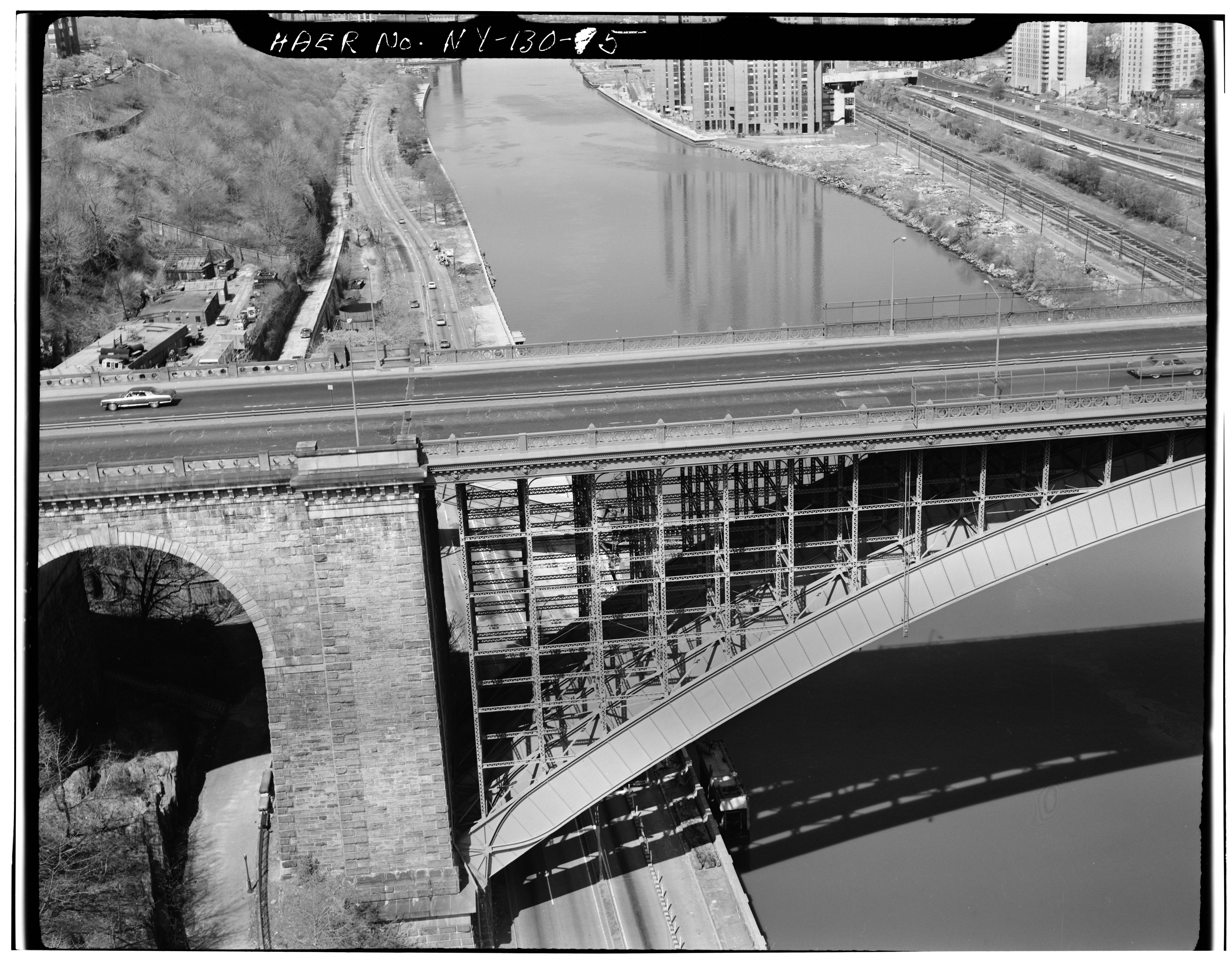
| DETAIL OF MASONRY ARCH APPROACH SPAN ON THE MANHATTAN SIDE - Washington Bridge, Spanning Harlem River at One-hundred-eighty-first, New York, New York County, NY | ||||
|---|---|---|---|---|
| Photographer |
Related names:
|
|||
| ခေါင်းစဉ် |
DETAIL OF MASONRY ARCH APPROACH SPAN ON THE MANHATTAN SIDE - Washington Bridge, Spanning Harlem River at One-hundred-eighty-first, New York, New York County, NY |
|||
| Depicted place | New York; New York County; New York | |||
| ရက်စွဲ | Documentation compiled after 1968 | |||
| ရှုထောင့်များ | 4 x 5 in. | |||
| လက်ရှိ တည်နေရာ |
Library of Congress Prints and Photographs Division Washington, D.C. 20540 USA http://hdl.loc.gov/loc.pnp/pp.print |
|||
| Accession number |
HAER NY,31-NEYO,162-5 |
|||
| အသိအမှတ်ပြုဖော်ပြ စာကြောင်း |
|
|||
| Notes |
|
|||
| ရင်းမြစ် | https://www.loc.gov/pictures/item/ny0979.photos.119115p | |||
| ခွင့်ပြုချက် (ဤဖိုင်ကို ပြန်လည်အသုံးပြုခြင်း) |
|
|||

| Object location | | View this and other nearby images on: OpenStreetMap |
|---|
ဖိုင်မှတ်တမ်း
ဖိုင်ကို ယင်းနေ့စွဲ အတိုင်း မြင်နိုင်ရန် နေ့စွဲ/အချိန် တစ်ခုခုပေါ်တွင် ကလစ်နှိပ်ပါ။
| နေ့စွဲ/အချိန် | နမူနာပုံငယ် | မှတ်တမ်း ဒိုင်မန်းရှင်းများ | အသုံးပြုသူ | မှတ်ချက် | |
|---|---|---|---|---|---|
| ကာလပေါ် | ၁၃:၁၈၊ ၂၉ ဇူလိုင် ၂၀၁၄ |  | ၅၀၀၀ × ၃၈၈၇ (၁၈.၅၄ MB) | Fæ | GWToolset: Creating mediafile for Fæ. HABS 24 July 2014 (2301:2600) |
ဖိုင်သုံးစွဲမှု
ဤဖိုင်ကို အသုံးပြုထားသော စာမျက်နှာများမရှိပါ။
ဂလိုဘယ် ဖိုင်သုံးစွဲမှု
အောက်ပါ အခြားဝီကီများတွင် ဤဖိုင်ကို အသုံးပြုထားသည်-
- ar.wikipedia.org တွင် အသုံးပြုမှု
- bn.wikipedia.org တွင် အသုံးပြုမှု
- en.wikipedia.org တွင် အသုံးပြုမှု
- gl.wikipedia.org တွင် အသုံးပြုမှု
- id.wikipedia.org တွင် အသုံးပြုမှု