
ဖိုင်:Crop spraying near St Mary Bourne - geograph.org.uk - 392462.jpg
သည်ထက်ကြီးသော resolution မရှိပါ.
Crop_spraying_near_St_Mary_Bourne_-_geograph.org.uk_-_392462.jpg (၆၄၀ × ၄၈၀ pixels, ဖိုင်အရွယ်အစား - ၁၄၃ KB, MIME အမျိုးအစား image/jpeg)
| ဤဖိုင်သည် Wikimedia Commons မှဖြစ်ပြီး အခြားပရောဂျက်များတွင် သုံးကောင်းသုံးလိမ့်မည်။ ယင်း၏ ဖိုင်အကြောင်းစာမျက်နှာ တွင် ဖော်ပြထားချက်ကို အောက်တွင် ပြထားသည်။ Commons သည် မူပိုင်ခွင့်လွတ်လပ်သော မီဒီယာဖိုင်များ သိုလှောင်ထားရာ နေရာ ဖြစ်သည်။ သင်လည်း ပါဝင်ကူညီနိုင်ပါသည်။ |
အကျဉ်းချုပ်
| ဖော်ပြချက် |
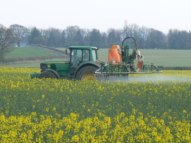
English: Crop spraying near St Mary Bourne. I know not whether the spray is herbicide, pesticide or fertiliser. The crop is rapeseed. Coming into full flower soon, the air was filled with its rather rank scent. The pylons in the background are about a kilometre south of the viewpoint. |
||
| ရက်စွဲ | |||
| ရင်းမြစ် | From geograph.org.uk | ||
| စာရေးသူ | Brian Robert Marshall | ||
| ခွင့်ပြုချက် (ဤဖိုင်ကို ပြန်လည်အသုံးပြုခြင်း) |
ဤဖိုင်သည် Creative Commons Attribution-Share Alike 2.0 Generic လိုင်စင်အောက်တွင် လိုင်စင်သတ်မှတ်ထားပါသည်။ မှတ်ယူနိုင်ခြင်း: Brian Robert Marshall
|
||
| မှတ်ယူနိုင်ခြင်း (required by the license) | Brian Robert Marshall / Crop spraying near St Mary Bourne / | ||

| Camera location | | View this and other nearby images on: OpenStreetMap |
|---|
_heading:135.00&language=my)
| Object location | | View this and other nearby images on: OpenStreetMap |
|---|
_heading:135.00&language=my)
ဖိုင်မှတ်တမ်း
ဖိုင်ကို ယင်းနေ့စွဲ အတိုင်း မြင်နိုင်ရန် နေ့စွဲ/အချိန် တစ်ခုခုပေါ်တွင် ကလစ်နှိပ်ပါ။
| နေ့စွဲ/အချိန် | နမူနာပုံငယ် | မှတ်တမ်း ဒိုင်မန်းရှင်းများ | အသုံးပြုသူ | မှတ်ချက် | |
|---|---|---|---|---|---|
| ကာလပေါ် | ၁၇:၂၄၊ ၃ ဖေဖော်ဝါရီ ၂၀၁၁ | | ၆၄၀ × ၄၈၀ (၁၄၃ KB) | GeographBot | == {{int:filedesc}} == {{Information |description={{en|1=Crop spraying near St Mary Bourne I know not whether the spray is herbicide, pesticide or fertiliser. The crop is rapeseed. Coming into full flower soon, the air was filled with its rather rank scen |
ဖိုင်သုံးစွဲမှု
ဤဖိုင်ကို အသုံးပြုထားသော စာမျက်နှာများမရှိပါ။
ဂလိုဘယ် ဖိုင်သုံးစွဲမှု
အောက်ပါ အခြားဝီကီများတွင် ဤဖိုင်ကို အသုံးပြုထားသည်-
- bn.wikipedia.org တွင် အသုံးပြုမှု
- ckb.wikipedia.org တွင် အသုံးပြုမှု
- cs.wikipedia.org တွင် အသုံးပြုမှု
- en.wikipedia.org တွင် အသုံးပြုမှု
- es.wikipedia.org တွင် အသုံးပြုမှု
- fa.wikipedia.org တွင် အသုံးပြုမှု
- fr.wikipedia.org တွင် အသုံးပြုမှု
- id.wikipedia.org တွင် အသုံးပြုမှု
- pt.wikipedia.org တွင် အသုံးပြုမှု
- vi.wikipedia.org တွင် အသုံးပြုမှု
- zh.wikipedia.org တွင် အသုံးပြုမှု