
ဖိုင်:Barrage de la Rance.jpg

ဤနမူနာ၏ အရွယ်အစား - ၈၀၀ × ၅၀၀ ပစ်ဇယ်။ အခြား ပုံရိပ်ပြတ်သားမှု: ၃၂၀ × ၂၀၀ ပစ်ဇယ် | ၆၄၀ × ၄၀၀ ပစ်ဇယ် | ၁၀၂၄ × ၆၃၉ ပစ်ဇယ် | ၁၂၈၀ × ၇၉၉ ပစ်ဇယ် | ၁၉၈၄ × ၁၂၃၉ ပစ်ဇယ်။
မူရင်းဖိုင် (၁၉၈၄ × ၁၂၃၉ pixels, ဖိုင်အရွယ်အစား - ၂.၅၇ MB, MIME အမျိုးအစား image/jpeg)
| ဤဖိုင်သည် Wikimedia Commons မှဖြစ်ပြီး အခြားပရောဂျက်များတွင် သုံးကောင်းသုံးလိမ့်မည်။ ယင်း၏ ဖိုင်အကြောင်းစာမျက်နှာ တွင် ဖော်ပြထားချက်ကို အောက်တွင် ပြထားသည်။ Commons သည် မူပိုင်ခွင့်လွတ်လပ်သော မီဒီယာဖိုင်များ သိုလှောင်ထားရာ နေရာ ဖြစ်သည်။ သင်လည်း ပါဝင်ကူညီနိုင်ပါသည်။ |
အကျဉ်းချုပ်
| ဖော်ပြချက် |
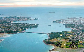
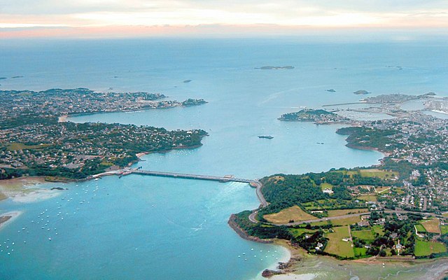
Français : Vue aérienne du barrage et usine marémotrice de La Rance avec en arrière plan Saint-Malo à droite de l'estuaire (Saint-Servan en premier plan, la cité d'Aleth sur la gauche, la ville intra-muros au fond après le port, et derrière celle-ci les îlots du Petit et du Grand Bé) et Dinard à gauche de l'estuaire. On aperçoit également le rocher de Bizieux (le plus proche du Barrage) et l'île de Cézembre (au fond, au centre).
English: Aerial view of the tidal barrage on the Rance and of Saint Malo.
Deutsch: Luftbild des Gezeitenkraftwerks Rance mit den Städten Saint-Malo auf der rechten Seite der Mündung und Dinard links. |
| ရက်စွဲ | |
| ရင်းမြစ် | ကိုယ်ပိုင်ဖန်တီးမှု |
| စာရေးသူ | Tswgb |
| အခြား ဗားရှင်းများ |

လိုင်စင်သတ်မှတ်ခြင်း
| I, the copyright holder of this work, release this work into the public domain. This applies worldwide. In some countries this may not be legally possible; if so: အကျွန်ုပ်သည် ဤဖန်တီးမှုလက်ရာကို ဥပဒေအရလိုအပ်ခြင်းမရှိသည့် မည်သည့်အခြေအနေမျိုးတွက်မဆို၊ မည်သို့သော ရည်ရွယ်ချက်အတွက်မဆို ၎င်းကို မည်သူမဆို အသုံးပြုပိုင်ခွင့်အား ပေးအပ်သည်။ |
ဖိုင်မှတ်တမ်း
ဖိုင်ကို ယင်းနေ့စွဲ အတိုင်း မြင်နိုင်ရန် နေ့စွဲ/အချိန် တစ်ခုခုပေါ်တွင် ကလစ်နှိပ်ပါ။
| နေ့စွဲ/အချိန် | နမူနာပုံငယ် | မှတ်တမ်း ဒိုင်မန်းရှင်းများ | အသုံးပြုသူ | မှတ်ချက် | |
|---|---|---|---|---|---|
| ကာလပေါ် | ၀၉:၁၂၊ ၁၄ အောက်တိုဘာ ၂၀၂၂ | | ၁၉၈၄ × ၁၂၃၉ (၂.၅၇ MB) | Rundvald | Amélioration de la colorimétrie, de la luminosité et des contrastes... |
| ၁၀:၄၄၊ ၁၀ မေ ၂၀၁၃ |  | ၁၄၄၀ × ၉၀၀ (၂၉၉ KB) | Chiswick Chap | contrast, unsharp mask | |
| ၀၂:၀၆၊ ၂၈ နိုဝင်ဘာ ၂၀၁၀ |  | ၁၄၄၀ × ၉၀၀ (၂၈၅ KB) | Rehman | focus on subject | |
| ၁၆:၁၂၊ ၄ ဒီဇင်ဘာ ၂၀၀၇ |  | ၁၆၀၀ × ၁၂၀၀ (၁၈၄ KB) | Tswgb | {{Information |Description=Aerial view of the tidal barrage on the Rance and of Saint Malo |Source=self-made |Date=20 June 2007 |Author= Tswgb |Permission= |other_versions= }} Category:Rance tidal power plantCategory:Saint-Malo |
ဖိုင်သုံးစွဲမှု
ဤဖိုင်ကို အသုံးပြုထားသော စာမျက်နှာများမရှိပါ။
ဂလိုဘယ် ဖိုင်သုံးစွဲမှု
အောက်ပါ အခြားဝီကီများတွင် ဤဖိုင်ကို အသုံးပြုထားသည်-
- af.wikipedia.org တွင် အသုံးပြုမှု
- br.wikipedia.org တွင် အသုံးပြုမှု
- da.wikipedia.org တွင် အသုံးပြုမှု
- de.wikipedia.org တွင် အသုံးပြုမှု
- de.wikivoyage.org တွင် အသုံးပြုမှု
- en.wikipedia.org တွင် အသုံးပြုမှု
- eo.wikipedia.org တွင် အသုံးပြုမှု
- es.wikipedia.org တွင် အသုံးပြုမှု
- fa.wikipedia.org တွင် အသုံးပြုမှု
- fi.wikipedia.org တွင် အသုံးပြုမှု
- fr.wikipedia.org တွင် အသုံးပြုမှု
- Énergie marémotrice
- Électricité en France
- Usine marémotrice de la Rance
- La Richardais
- Bretagne (région administrative)
- Liste des ponts sur la Rance
- Rocher de Bizeux
- Wikipédia:Oracle/semaine 15 2012
- Liste des estuaires de France
- Utilisateur:Olyon01/Brouillon11
- Utilisateur:Olyon01/Brouillon12
- Utilisateur:Olyon01/Brouillon13
- fr.wikiversity.org တွင် အသုံးပြုမှု
- fr.wiktionary.org တွင် အသုံးပြုမှု
- gl.wikipedia.org တွင် အသုံးပြုမှု
- hr.wikipedia.org တွင် အသုံးပြုမှု
- id.wikipedia.org တွင် အသုံးပြုမှု
ဤဖိုင်ကို အခြားနေရာများတွင် အသုံးပြုထားမှုများအား ကြည့်ရှုရန်။