
ဖိုင်:Baikal-S1999276045323.png

ဤနမူနာ၏ အရွယ်အစား - ၈၀၀ × ၅၆၃ ပစ်ဇယ်။ အခြား ပုံရိပ်ပြတ်သားမှု: ၃၂၀ × ၂၂၅ ပစ်ဇယ် | ၆၄၀ × ၄၅၀ ပစ်ဇယ် | ၁၀၂၄ × ၇၂၀ ပစ်ဇယ် | ၁၂၂၀ × ၈၅၈ ပစ်ဇယ်။
မူရင်းဖိုင် (၁၂၂၀ × ၈၅၈ pixels, ဖိုင်အရွယ်အစား - ၁.၉ MB, MIME အမျိုးအစား image/png)
| ဤဖိုင်သည် Wikimedia Commons မှဖြစ်ပြီး အခြားပရောဂျက်များတွင် သုံးကောင်းသုံးလိမ့်မည်။ ယင်း၏ ဖိုင်အကြောင်းစာမျက်နှာ တွင် ဖော်ပြထားချက်ကို အောက်တွင် ပြထားသည်။ Commons သည် မူပိုင်ခွင့်လွတ်လပ်သော မီဒီယာဖိုင်များ သိုလှောင်ထားရာ နေရာ ဖြစ်သည်။ သင်လည်း ပါဝင်ကူညီနိုင်ပါသည်။ |
| ဖော်ပြချက် |
Čeština: Bajkal
|
||||
| ရက်စွဲ | |||||
| ရင်းမြစ် | http://visibleearth.nasa.gov/view_rec.php?id=1002 - http://visibleearth.nasa.gov/images/1002/S1999276045323.png | ||||
| စာရေးသူ | Provided by the SeaWiFS Project, NASA/Goddard Space Flight Center, and ORBIMAGE | ||||
| ခွင့်ပြုချက် (ဤဖိုင်ကို ပြန်လည်အသုံးပြုခြင်း) |
|
ဖိုင်မှတ်တမ်း
ဖိုင်ကို ယင်းနေ့စွဲ အတိုင်း မြင်နိုင်ရန် နေ့စွဲ/အချိန် တစ်ခုခုပေါ်တွင် ကလစ်နှိပ်ပါ။
| နေ့စွဲ/အချိန် | နမူနာပုံငယ် | မှတ်တမ်း ဒိုင်မန်းရှင်းများ | အသုံးပြုသူ | မှတ်ချက် | |
|---|---|---|---|---|---|
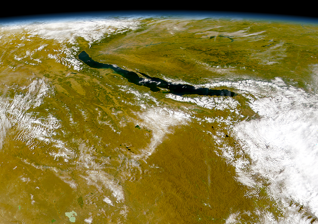
| ကာလပေါ် | ၀၃:၅၇၊ ၂၁ ဇူလိုင် ၂၀၀၅ | | ၁၂၂၀ × ၈၅၈ (၁.၉ MB) | Bdk | Lake Baikal *Source: http://visibleearth.nasa.gov/view_rec.php?id=1002 - http://visibleearth.nasa.gov/images/1002/S1999276045323.png *Sensor OrbView-2/SeaWiFS *Dates: Datastart 1999-10-03 - Visualization Date 1999-10-03 *Visible Earth v1 ID 3678 *Credit: |
ဖိုင်သုံးစွဲမှု
အောက်ပါ စာမျက်နှာ သည် ဤဖိုင်ကို အသုံးပြုထားသည်:
ဂလိုဘယ် ဖိုင်သုံးစွဲမှု
အောက်ပါ အခြားဝီကီများတွင် ဤဖိုင်ကို အသုံးပြုထားသည်-
- arz.wikipedia.org တွင် အသုံးပြုမှု
- ast.wikipedia.org တွင် အသုံးပြုမှု
- as.wikipedia.org တွင် အသုံးပြုမှု
- az.wikipedia.org တွင် အသုံးပြုမှု
- be.wikipedia.org တွင် အသုံးပြုမှု
- ca.wikipedia.org တွင် အသုံးပြုမှု
- ce.wikipedia.org တွင် အသုံးပြုမှု
- crh.wikipedia.org တွင် အသုံးပြုမှု
- cs.wikipedia.org တွင် အသုံးပြုမှု
- cy.wikipedia.org တွင် အသုံးပြုမှု
- de.wikipedia.org တွင် အသုံးပြုမှု
- de.wikivoyage.org တွင် အသုံးပြုမှု
- de.wiktionary.org တွင် အသုံးပြုမှု
- diq.wikipedia.org တွင် အသုံးပြုမှု
- el.wikipedia.org တွင် အသုံးပြုမှု
- en.wikipedia.org တွင် အသုံးပြုမှု
- eo.wikipedia.org တွင် အသုံးပြုမှု
- es.wikipedia.org တွင် အသုံးပြုမှု
- eu.wikipedia.org တွင် အသုံးပြုမှု
- fa.wikipedia.org တွင် အသုံးပြုမှု
- fr.wikivoyage.org တွင် အသုံးပြုမှု
- ga.wikipedia.org တွင် အသုံးပြုမှု
- he.wikipedia.org တွင် အသုံးပြုမှု
- hr.wikipedia.org တွင် အသုံးပြုမှု
- hu.wikipedia.org တွင် အသုံးပြုမှု
- hy.wikipedia.org တွင် အသုံးပြုမှု
- it.wikipedia.org တွင် အသုံးပြုမှု
- ja.wikipedia.org တွင် အသုံးပြုမှု
- ka.wikipedia.org တွင် အသုံးပြုမှု
- kbp.wikipedia.org တွင် အသုံးပြုမှု
- kk.wikipedia.org တွင် အသုံးပြုမှု
- lb.wikipedia.org တွင် အသုံးပြုမှု
- lmo.wikipedia.org တွင် အသုံးပြုမှု
- lv.wikipedia.org တွင် အသုံးပြုမှု
- mhr.wikipedia.org တွင် အသုံးပြုမှု
- myv.wikipedia.org တွင် အသုံးပြုမှု
- mzn.wikipedia.org တွင် အသုံးပြုမှု
- nn.wikipedia.org တွင် အသုံးပြုမှု
- no.wikipedia.org တွင် အသုံးပြုမှု
ဤဖိုင်ကို အခြားနေရာများတွင် အသုံးပြုထားမှုများအား ကြည့်ရှုရန်။