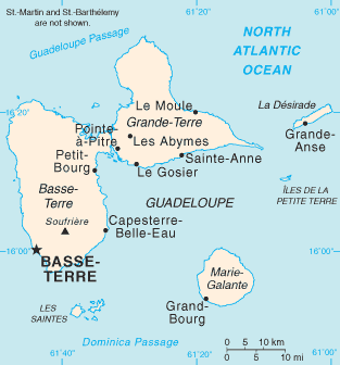
ဖိုင်:Guadeloupe map.png
Guadeloupe_map.png (၃၁၃ × ၃၃၆ pixels, ဖိုင်အရွယ်အစား - ၁၁ KB, MIME အမျိုးအစား image/png)
ဖိုင်မှတ်တမ်း
ဖိုင်ကို ယင်းနေ့စွဲ အတိုင်း မြင်နိုင်ရန် နေ့စွဲ/အချိန် တစ်ခုခုပေါ်တွင် ကလစ်နှိပ်ပါ။
| နေ့စွဲ/အချိန် | နမူနာပုံငယ် | မှတ်တမ်း ဒိုင်မန်းရှင်းများ | အသုံးပြုသူ | မှတ်ချက် | |
|---|---|---|---|---|---|
| ကာလပေါ် | ၁၉:၁၃၊ ၃၀ အောက်တိုဘာ ၂၀၂၁ |  | ၃၁၃ × ၃၃၆ (၁၁ KB) | Auguel | Remove frame |
| ၀၉:၅၈၊ ၁ ဇူလိုင် ၂၀၀၆ |  | ၃၁၅ × ၃၃၇ (၁၀ KB) | ArturM | Map of the French overseas département of Guadeloupe from the CIA World Factbook. http://www.cia.gov/cia/publications/factbook/geos/gp.html {{PD-USGov-CIA-WF}} |
ဖိုင်သုံးစွဲမှု
အောက်ပါ စာမျက်နှာ သည် ဤဖိုင်ကို အသုံးပြုထားသည်:
ဂလိုဘယ် ဖိုင်သုံးစွဲမှု
အောက်ပါ အခြားဝီကီများတွင် ဤဖိုင်ကို အသုံးပြုထားသည်-
- af.wikipedia.org တွင် အသုံးပြုမှု
- ar.wikipedia.org တွင် အသုံးပြုမှု
- azb.wikipedia.org တွင် အသုံးပြုမှု
- az.wikipedia.org တွင် အသုံးပြုမှု
- ban.wikipedia.org တွင် အသုံးပြုမှု
- be-tarask.wikipedia.org တွင် အသုံးပြုမှု
- bg.wikipedia.org တွင် အသုံးပြုမှု
- bn.wikipedia.org တွင် အသုံးပြုမှု
- br.wikipedia.org တွင် အသုံးပြုမှု
- bs.wikipedia.org တွင် အသုံးပြုမှု
- bug.wikipedia.org တွင် အသုံးပြုမှု
- ca.wikipedia.org တွင် အသုံးပြုမှု
- ceb.wikipedia.org တွင် အသုံးပြုမှု
- cs.wikipedia.org တွင် အသုံးပြုမှု
- cy.wikipedia.org တွင် အသုံးပြုမှု
- da.wikipedia.org တွင် အသုံးပြုမှု
- de.wikipedia.org တွင် အသုံးပြုမှု
- dsb.wikipedia.org တွင် အသုံးပြုမှု
- el.wikipedia.org တွင် အသုံးပြုမှု
- en.wikipedia.org တွင် အသုံးပြုမှု
- Guadeloupe
- Communes of the Guadeloupe department
- Grande-Terre
- La Désirade
- Marie-Galante
- List of airports in Guadeloupe
- Dominica Passage
- Guadeloupe Passage
- Portal:Caribbean/Selected geography article
- Portal:Caribbean/Selected geography article/13
- Petite Terre Islands
- Index of Guadeloupe-related articles
- Troude's expedition to the Caribbean
- 2009 French Caribbean general strikes
- Action of 22 January 1809
- Invasion of Guadeloupe (1810)
- Siege of Guadeloupe
- List of amphibians and reptiles of Guadeloupe
- Les Saintes Passage
- Marie-Galante Passage
- Module:Location map/data/Guadeloupe/doc
- Invasion of Guadeloupe (1815)
- Petite Terre Islands National Nature Reserve
ဤဖိုင်ကို အခြားနေရာများတွင် အသုံးပြုထားမှုများအား ကြည့်ရှုရန်။


