
ဖိုင်:Egypt location map.svg

Size of this PNG preview of this SVG file: ၆၅၀ × ၅၉၉ ပစ်ဇယ်. အခြား ပုံရိပ်ပြတ်သားမှု: ၂၆၀ × ၂၄၀ ပစ်ဇယ် | ၅၂၀ × ၄၈၀ ပစ်ဇယ် | ၈၃၃ × ၇၆၈ ပစ်ဇယ် | ၁၁၁၀ × ၁၀၂၄ ပစ်ဇယ် | ၂၂၂၁ × ၂၀၄၈ ပစ်ဇယ် | ၁၀၅၅ × ၉၇၃ ပစ်ဇယ်။
မူရင်းဖိုင် (SVG ဖိုင်, ၁၀၅၅ × ၉၇၃ pixels ကို အကြံပြုသည်, ဖိုင်အရွယ်အစား - ၃၂၄ KB)
| ဤဖိုင်သည် Wikimedia Commons မှဖြစ်ပြီး အခြားပရောဂျက်များတွင် သုံးကောင်းသုံးလိမ့်မည်။ ယင်း၏ ဖိုင်အကြောင်းစာမျက်နှာ တွင် ဖော်ပြထားချက်ကို အောက်တွင် ပြထားသည်။ Commons သည် မူပိုင်ခွင့်လွတ်လပ်သော မီဒီယာဖိုင်များ သိုလှောင်ထားရာ နေရာ ဖြစ်သည်။ သင်လည်း ပါဝင်ကူညီနိုင်ပါသည်။ |

|
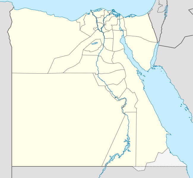
The boundaries on this map show the de facto situation. This is just one of several different views on the subject (see COM:NPOV). |
အကျဉ်းချုပ်
| ဖော်ပြချက် |
Deutsch: Positionskarte von Ägypten
Quadratische Plattkarte, N-S-Streckung 111,8685 %. Geographische Begrenzung der Karte:
English: Location map of Egypt
Equirectangular projection, N/S stretching 111.8685 %. Geographic limits of the map:
中文(繁體):埃及位置地圖
等距矩形投影,南北拉伸111.8685%。地圖地理界線:
|
| ရက်စွဲ | 10-08-2008 |
| ရင်းမြစ် |
own work, using
|
| စာရေးသူ | NordNordWest |
| အခြား ဗားရှင်းများ |
Derivative works of this file:
|


|
This map has been made or improved in the German Kartenwerkstatt (Map Lab). You can propose maps to improve as well.
|
လိုင်စင်သတ်မှတ်ခြင်း
ကျွန်ုပ်၊ ဤလုပ်ဆောင်ချက်၏ မူပိုင်ခွင့်ပိုင်ရှင်အနေဖြင့် ဤနေရာမှ အောက်ပါလိုင်စင်များအောက်တွင် ထုတ်လွှင့်ပါသည်:

|
ဤစာတမ်းကို GNU Free Documentation License, ဗားရှင်း ၁.၂ သို့မဟုတ် Free Software Foundation မှ ဖြန့်ချီထားသော မည်သည့်ယခင်ဗားရှင်းတစ်ခုခုအောက်တွင် Invariant Sections, Front-Cover Texts နှင့် Back-Cover Texts များမပါဝင်ဘဲ ကူးယူခြင်း၊ ဖြန့်ချီခြင်း နှင့်/သို့မဟုတ် ပြင်ဆင်ပြောင်းလဲနိုင်ရန် ခွင့်ပြုသည်။ လိုင်စင်မူပွားကို GNU Free Documentation License ခေါင်းစဉ်အောက်တွင် ထည့်သွင်းထားသည်။ |
ဤဖိုင်ကို Creative Commons Attribution-Share Alike 3.0 Unported လိုင်စင်ဖြင့် သတ်မှတ်ထားသည်။
- သင်သည် လွတ်လပ်စွာ:
- မျှဝေရန် – ဖန်တီးမှုကို ကူးယူရန်၊ ဖြန့်ဖြူးရန်နှင့် ထုတ်လွှင့်ရန်
- ပြန်ရောနှောရန် – ဖန်တီးမှုကို ပြင်ဆင်ညှိနှိုင်းရန်
- အောက်ပါ အခြေအနေများတွင်:
- မှတ်ယူနိုင်ခြင်း – ပြောင်းလဲမှုများ ပြုလုပ်ခဲ့ပါက ဖန်တီးသူ သို့မဟုတ် လိုင်စင်ရှိသူမှ သတ်မှတ်သော အမျိုးအစားကို လိုက်နာရမည် (ဆိုလိုသည်မှာ သင့်အား သို့မဟုတ် သင့်ဖန်တီးမှုတွင် အသုံးပြုခြင်းအား ထောက်ခံချက်ပေးသည်ဟု မဆိုလိုပါ)။
- ထပ်တူမျှဝေ – ဤဖန်တီးမှုအား ပြင်ဆင်ခြင်း၊ ပြောင်းလဲခြင်း သို့မဟုတ် ထပ်ဆင့် ဖန်တီးခြင်း ပြုလုပ်ပါက ရရှိလာသော ဖန်တီးမှုကို ဤဖန်တီးမှုနှင့် သို့မဟုတ် ဆင်တူသော လိုင်စင်ဖြင့်သာ ဖြန့်ချိသင့်သည်။
သင်အလိုရှိရာ လိုင်စင်ကို ရွေးချယ်နိုင်ပါသည်။
| Annotations | This image is annotated: View the annotations at Commons |
ဖိုင်မှတ်တမ်း
ဖိုင်ကို ယင်းနေ့စွဲ အတိုင်း မြင်နိုင်ရန် နေ့စွဲ/အချိန် တစ်ခုခုပေါ်တွင် ကလစ်နှိပ်ပါ။
| နေ့စွဲ/အချိန် | နမူနာပုံငယ် | မှတ်တမ်း ဒိုင်မန်းရှင်းများ | အသုံးပြုသူ | မှတ်ချက် | |
|---|---|---|---|---|---|
| ကာလပေါ် | ၂၁:၃၅၊ ၁၂ ဖေဖော်ဝါရီ ၂၀၁၃ | | ၁၀၅၅ × ၉၇၃ (၃၂၄ KB) | NordNordWest | upd |
| ၁၆:၀၃၊ ၁၇ ဧပြီ ၂၀၁၁ |  | ၁၀၅၅ × ၉၇၃ (၃၅၁ KB) | NordNordWest | upd | |
| ၁၇:၀၃၊ ၇ မတ် ၂၀၁၀ |  | ၁၀၅၅ × ၉၇၃ (၅၅၃ KB) | NordNordWest | resize | |
| ၁၀:၄၈၊ ၃ စက်တင်ဘာ ၂၀၀၉ |  | ၁၀၅၅ × ၉၅၆ (၅၅၂ KB) | NordNordWest | ||
| ၁၉:၁၀၊ ၂၃ မေ ၂၀၀၉ |  | ၁၀၅၆ × ၉၅၉ (၅၅၇ KB) | NordNordWest | corr | |
| ၁၁:၁၂၊ ၁၀ ဩဂုတ် ၂၀၀၈ |  | ၁၀၅၆ × ၉၅၇ (၄၉၁ KB) | NordNordWest | {{Information |Description= {{de|Positionskarte von Ägypten}} Quadratische Plattkarte, N-S-Streckung 110 %. Geographische Begrenzung der Karte: * N: 32.1° N * S: 21.3° N * W: 24.2° O * O: 37.3° O {{en|Location map of [[:en:Egypt|Egyp |
ဖိုင်သုံးစွဲမှု
အောက်ပါ စာမျက်နှာ သည် ဤဖိုင်ကို အသုံးပြုထားသည်:
ဂလိုဘယ် ဖိုင်သုံးစွဲမှု
အောက်ပါ အခြားဝီကီများတွင် ဤဖိုင်ကို အသုံးပြုထားသည်-
- af.wikipedia.org တွင် အသုံးပြုမှု
- als.wikipedia.org တွင် အသုံးပြုမှု
- am.wikipedia.org တွင် အသုံးပြုမှု
- ar.wikipedia.org တွင် အသုံးပြုမှု
- كأس الأمم الإفريقية 2006
- كأس الأمم الإفريقية 1986
- حمام مصري
- قالب:خريطة مواقع مصر
- كأس العالم تحت 20 سنة لكرة القدم 2009
- سد الكفرة
- كأس الأمم الإفريقية 2019
- الدوري المصري الممتاز 2015–16
- الدوري المصري الممتاز 2016–17
- البطولة العربية لكرة القدم النسائية 2006
- هجوم بئر العبد (أكتوبر 2016)
- كأس العالم تحت 19 سنة لكرة السلة 2017
- البطولة العربية للأندية 2016–17
- الدوري المصري الممتاز 2017–18
- قائمة ملاعب كرة القدم في مصر
- الدوري المصري الممتاز 2018–19
- الدوري المصري الممتاز 2019–20
- تصنيف:مسلسلات تلفزيونية مصرية تقع أحداثها في الصعيد
- مطار البردويل الدولي
- قاعدة الإسماعيلية الجوية
- قاعدة العامرية الجوية
- قاعدة الضبعة الجوية
- قاعدة كبريت الجوية
- جبل سيناء (مكان مقدس)
- الدوري المصري الممتاز 2020–21
- مرسى ثلمت
- كأس العرب لكرة الصالات 2021
- رأس مسلة
- الدوري المصري الممتاز 2021–22
- راس عسران
- راس بكر
- مرسى أم موريكا
- شرم المية
- رأس نصراني
- جزر القلعان
- أرض الهبوط 174
- مطار سيدي حنيش
ဤဖိုင်ကို အခြားနေရာများတွင် အသုံးပြုထားမှုများအား ကြည့်ရှုရန်။